The Apps I Actually Run Before and During an Offshore Trip
Six apps live on my phone for every offshore trip, and they split cleanly into two jobs: deciding whether to go, and then actually finding fish, staying legal, and getting home once I’m out there. I’ve already written up the weather stack — NOAA, Fish Weather, and Windy — and the full ActiveCaptain breakdown in their own dedicated pieces, so this is the shorter version of all four plus the two that don’t get talked about enough: RipCharts, for actually finding where the fish are before the boat leaves the dock, and Fish Rules, for knowing what’s actually legal to keep once you’ve caught something.
The planning phase: is today even worth it
NOAA’s marine forecast is the baseline everything else gets checked against. It’s not customized to your GPS pin and it’s not pretty, but it’s the one source that will flat-out tell you not to go with an actual small craft advisory or gale warning, not just a number that looks a little high. Check it first, every time.
Fish Weather is the fast buoy-based glance — real NOAA station data tied to an actual spot on the water, good for a quick gut check on wind and wave before digging into anything deeper. Worth knowing if you dig into the model picker: the free tier covers real stations, tides and currents, NWS marine forecasts, and basic alerts, while the locked “Pro” models in the forecast table — their in-house WRF 26 model down to 3km resolution, and NOAA’s 3km HRRR — sit behind a Plus/Pro subscription (roughly $5-15/month depending on tier). The free version is plenty for most routine trip decisions.
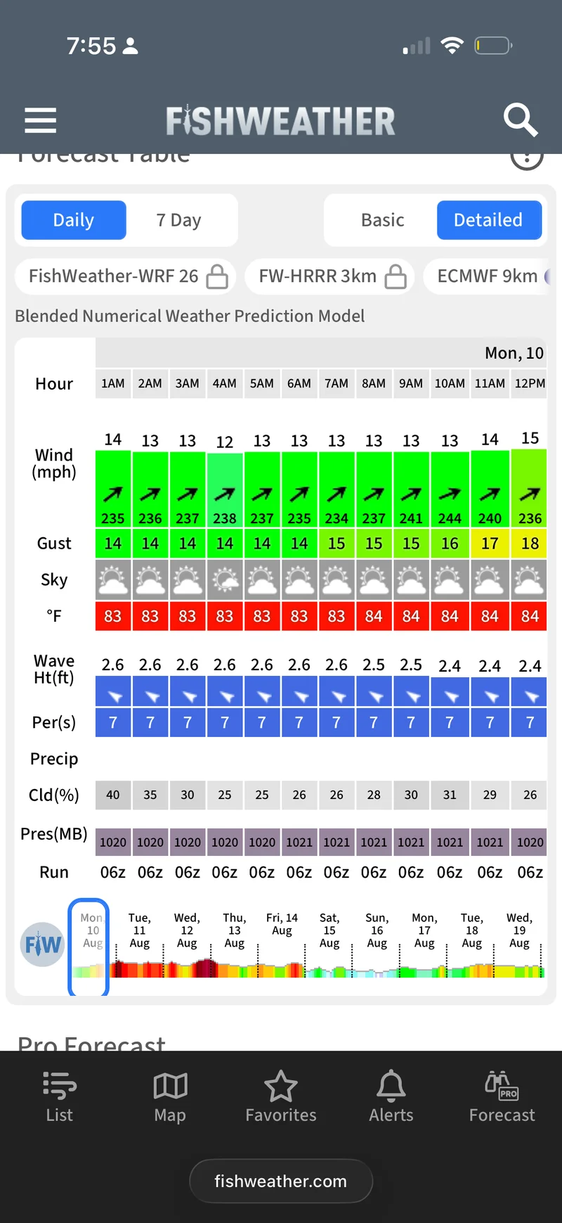
Windy is where the real planning happens once the first two say the day is a go — saved GPS spots, and wind/wave/swell as separate layers you can actually read independently instead of guessing what’s baked into one number.
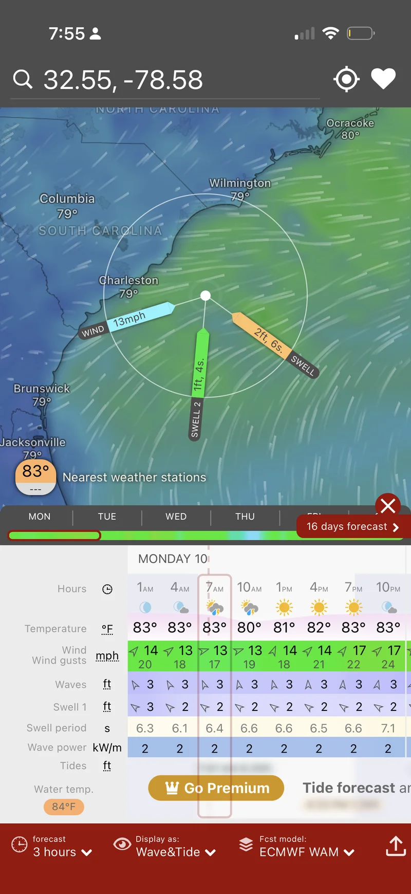
That screenshot is a good example of exactly why the separate layers matter: 13mph wind, but two different swells running at once — a 2ft groundswell on a 6-second period and a smaller 1ft wind swell on a 4-second period. A forecast that just said “2 feet” would hide that there are two different wave trains crossing each other, which is the kind of thing that turns a canyon run choppy even when the wind number alone looks fine. Full breakdown of all three weather apps, including how I actually stack them together, is in the dedicated weather apps article.
RipCharts: finding the fish before you leave the dock
Weather answers “can I go.” RipCharts answers “where do I actually run to once I’m out there,” and it’s the one app on this list that most weekend anglers have never opened.
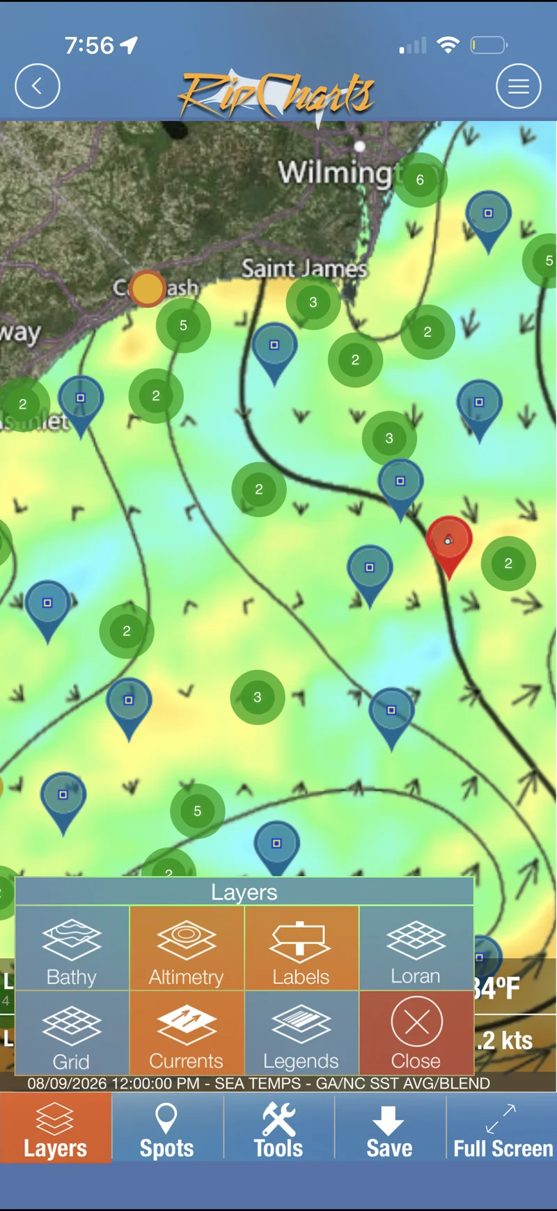
It’s a satellite oceanography service — sea surface temperature, chlorophyll/water clarity, altimetry, bathymetry, and surface current overlays, all mapped over the same coastline you’re planning to fish. The layer panel in the screenshot above is the real feature list: Bathy for bottom contour, Altimetry for sea surface height (upwellings vs. downwellings — a big deal for finding where warm water is actually pushing up nutrient-rich cooler water underneath it), Currents for surface flow direction, plus Grid, Loran, and Labels for actually navigating the chart. The black flow lines running across that screenshot are current data, not decoration — that’s the same kind of temperature-break-plus-current-edge reading covered in more depth in the SST and chlorophyll temperature break guide, applied to a dedicated charting tool instead of a general satellite viewer.
The access model is worth knowing before you get attached to a feature: guest and free accounts only see imagery older than 5 days, and the most recent (and most useful) 5 days of data sit behind a paid, region-based subscription — you pay per coastal region you want current access to, not one flat fee for the whole map. Premium membership also unlocks the mobile app’s offline mode: preload a chart while you’ve got signal at the dock, then navigate it by phone GPS once you’re out of range with no data connection needed. If you fish the same stretch of coast every weekend, one region’s subscription is a small, recurring cost for genuinely current SST and altimetry data instead of a five-day-old picture of where the edge used to be.
The daily summary and 3-day composite views are worth using specifically because of cloud cover — satellite SST imagery is blind wherever there’s cloud between the satellite and the water, and a composite view fills in those gaps from imagery taken on a clearer day nearby, so you’re not stuck with a chart that’s half missing data the one day it’s overcast.
Fish Rules: knowing what you can actually keep
Weather and RipCharts get you to the fish. Fish Rules is the one that keeps you legal once you’ve caught them, and it earns a spot on this list because regulations change often enough — and vary enough by species, size, and zone — that “I think it’s in season” isn’t good enough offshore.
It’s a free regulations lookup app from Fish Rules, LLC (now co-branded with Fishbrain), covering recreational saltwater regulations for state and federal waters from Maine to Texas, plus Hawaii and the Caribbean — solid coverage for the whole mid-Atlantic and Carolinas run. Pull it up and it shows, species by species, whether something’s in season, the bag and vessel limits, the size limit, and whether gear requirements like circle hooks, dehooking tools, or venting tools apply to what you’re targeting. The data comes straight from the actual regulatory bodies — Florida FWC, the South Atlantic Fishery Management Council, the Gulf Council, and others — kept current through the season rather than a static PDF you downloaded in the spring.
The genuinely useful part offshore is the GPS and calendar behavior: the app uses your phone’s location and the date to show only the regulations that actually apply to where and when you’re fishing, so you’re not scrolling past a dozen other states’ rules to find yours. Out of cell range, you can manually enter a location or lat/long instead and still pull the right regs with no signal — worth setting up before you leave the dock rather than discovering it doesn’t work thirty miles out. It also doubles as a species ID tool with illustrated swipe cards, which is a fair backup for a fish you’re not 100% sure of. A paid #ProStaff tier (around $30) strips ads and adds thousands of reef locations, bookmarked waypoints, and human-reviewed fish ID with about a 48-hour turnaround, but the free version covers the actual job this app needs to do.
While you’re on the water: ActiveCaptain
Once the boat’s actually moving, ActiveCaptain takes over as the on-the-water piece for anyone running Garmin electronics — syncing waypoints and tracks between phone and chartplotter, pushing firmware to every networked device instead of just the screen, and surfacing crowd-sourced marina, anchorage, and fuel dock reviews for anywhere new you’re running. It’s not a weather or fish-finding app; it’s the maintenance and information layer that keeps the rest of the electronics current and gives you real local intel on an inlet or marina you haven’t run before.
How the six actually fit together
In order, start to finish: NOAA for the official word and any advisories, Fish Weather for a fast buoy-based sanity check, Windy for the real planning detail on wind, swell, and swell period at saved spots. That’s the go/no-go decision. Then RipCharts, run separately, for where to actually point the bow once the answer is yes — reading SST breaks and altimetry against the same grounds you fish regularly. Fish Rules gets a check before you leave the dock too, so you’re not planning a trip around a species that’s closed, and it stays open on the phone once you’re catching, since size and bag limits are exactly the thing you want confirmed before something goes in the box instead of after. ActiveCaptain rides along once the boat leaves the dock, keeping waypoints synced and surfacing local knowledge if the trip takes you somewhere unfamiliar.
Once you’re actually anchored up or working a temperature break, our own Live Buoy Conditions map and Solunar Bite Times calculator cover the same real-time and bite-timing questions with no separate app or subscription.
Bottom line
Six apps, three questions: should I go, where do I go once I have, and what am I actually allowed to keep. NOAA, Fish Weather, and Windy answer the first one and are covered in full in their own article. RipCharts answers the second, turning satellite SST and altimetry data into an actual run plan instead of a guess based on last week’s water. Fish Rules answers the third, and it’s the one with real legal consequences if you skip it. ActiveCaptain keeps the electronics and local knowledge current once you’re moving. None of it replaces local knowledge or a good depth sounder, but running the stack in order has turned more than one trip from a guess into an actual plan.
This article may contain affiliate links. If you buy through them, we may earn a small commission at no extra cost to you. Learn more.